
The 2022-2023 winter is going to be heavily influenced by a persistent La Niña, which will bring warmer but more variable temperatures and below-average snowfall to Eastern Pennsylvania.
With models predicting a winter dominated by a continued La Niña, warmer and drier conditions are expected for the South, the East Coast, and the Gulf Coast. This is because the increase in trade winds in the South Pacific associated with a La Niña causes upwelling along the west coast of South America, bringing cooler waters to the surface of the equatorial Eastern Pacific.
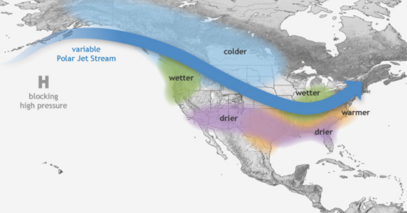
The cooler equatorial water displaces warmer waters to the western and northern Pacific Oceans, inducing above-average sea surface temperatures in those regions. Due to the warmer sea surface temperatures, a persistent upper-level high-pressure system forms over the North Pacific.
This blocking high pressure distorts the jet stream, causing it to bend into a U-shape over interior North America. Since polar air resides north of the jet stream while warmer air stays south of it, areas within the U face colder weather while areas outside of the bend experience warmer conditions. Additionally, storms tend to track along the jet stream, leading to above-average rainfall for areas under the jet stream like the Pacific Northwest, Northern Plains, and Midwest.
As eastern Pennsylvania is located slightly southeast of the jet stream, this winter is expected to have marginally above-average temperatures and near-average rainfall. The majority of days over the next few months will be in the low 30s and high 40s. While an average amount of precipitation is expected, snowfall will be below the average of 23 inches, with 14-20 inches of snow expected according to AccuWeather.
However, winter weather this year is not expected to stay confined to the weather conditions described above. All of those predicted factors are averages, based on the most predominant position of the jet stream. Since the blocking high pressure also weakens the jet stream, arctic and tropical air tend to move away from their expected locations. As a result, more frequent and severe cold spells and potential snow storms will occur throughout this winter, especially during mid December and January.
On the coldest days of the year where arctic air plunges into our region, we could see lows into the single digits and highs in the upper 20s. As for a white Christmas, the models are trending towards a potentially powerful Nor’easter striking the northeast on the third week of December, which would bring stormy weather to Christmas week and possibly snow.