
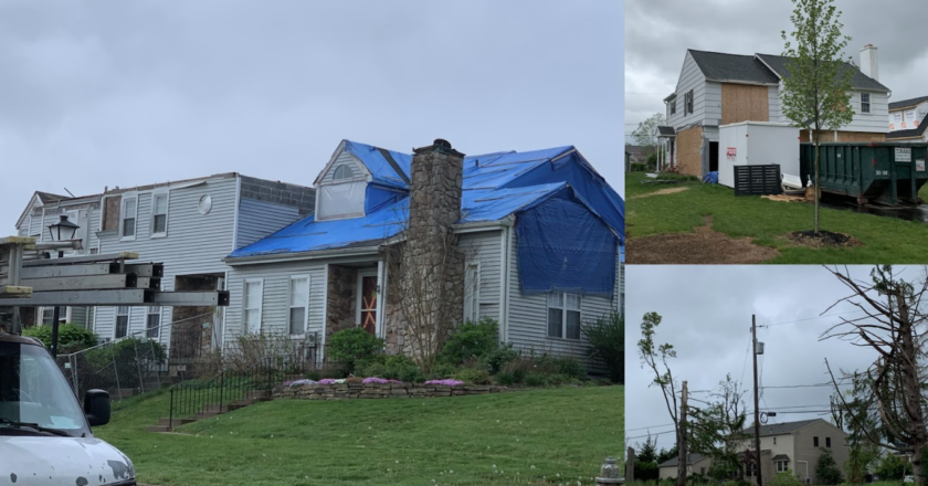
If you go through Upper Dublin today, seven months after Hurricane Ida swept through, you will still find dead trees, debris, and several houses covered in scaffolding still waiting to be fixed. As the most impactful storm of this school year, it raises many questions regarding the safety of our community.
Why was the greater Philly area, a region where tornado threats are usually negligible, hit by seven tornadoes on the same night? Will we be hit by such a storm again next hurricane season, or was Ida just a freak event?
As the remnants of Hurricane Ida traveled toward Philadelphia, it still had a deep layer of warm air that contained high amounts of moisture. When a cold front and another associated low pressure collided with the humid air, it was forced upwards, causing cumulus clouds to rapidly race towards the tropopause.
As this rising air encountered high winds from the jet stream, it started rotating, creating several supercells. Supercells are the most powerful type of thunderstorm, most commonly found in the Great Plains where warm air from the Gulf of Mexico collides with dry air from the southwest. They can generate numerous tornadoes, hail, and extremely heavy rain.
As multiple supercells passed over the I-95 corridor, rainfall totals rapidly increased while tornadoes touched down in multiple locations around Philadelphia. Additionally, according to local NOAA meteorologist Sarah Johnson, the ground was already nearly saturated due to a relatively wet pattern in July and August – including Tropical Storm Henri which brought heavy rain to the region just one week prior. When the ground is already close to being saturated, it will not be able to absorb as much additional rainfall so flooding can occur quicker with rain events. The perfect recipe for disaster had been created.
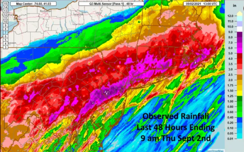
Image Credit: National Weather Service
Overnight, torrential rain fell across the I-95 corridor, and totals in Fort Washington reached 5.53 inches. For reference, the average monthly rainfall in Fort Washington is 3.7 inches. In New Hope, rainfall totals reached up to 8.5 inches.
These heavy rains raised the water levels of the Neshaminy and Wissahickon creeks by 20.8 and 18 feet, respectively, causing significant flooding along their banks. Additionally, 7 tornadoes touched down near Philadelphia, including a damaging EF2 that struck Fort Washington, a powerful EF3 in Gloucester, and an EF1 that struck near Doylestown.
Unfortunately, events similar to Hurricane Ida are not uncommon and happen around every decade. Johnson states, “Tropical systems taking a track similar to Ida–making landfall in the Gulf of Mexico, and then progressing northeastward to the Mid Atlantic–is a relatively common occurrence…Other storms that have taken similar tracks with significant flooding include Tropical Storm Lee in 2011 and Hurricane Agnes in 1972.”
In addition, there was a similar tornado-producing tropical storm that struck in 2021; Tropical Storm Fred. Although Fred wasn’t as impactful with respect to flooding, it did produce three minor tornadoes in southeastern PA.
Whether a tropical system takes a path like Ida, or a different one like Sandy (2012) or Isaias (2020), heavy rain, flooding, and sometimes tornadoes can be a concern if the system ends up near our region. Since meteorologists project the 2022 hurricane season to be above average, more hurricanes are expected to hit the United States, and there is an elevated chance for another storm like Ida.
Knowing this risk, GA community members should be well-prepared for flooding and tornado events. Johnson suggests that a GA should have a weather safety plan for various weather hazards like tornadoes and flooding.
The safety plan should include information on how weather watches and warnings will be received, where the best place is to shelter during these hazards, how to inform the entire campus of the need to shelter, and possibly other items depending on the needs of individual schools. Additionally, it is vital for GA students and parents to develop a home weather safety plan.